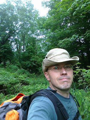
I got into town late on Friday night, and I had made plans to have a cookout with my sister and her kids at 6:00 on Saturday night. I estimated that I had to start hiking not long after 7:00 AM in order to have time to stop for lunch and rest my feet in Cazenovia before turning around and getting back on time. This meant that I only had time for about four hours of sleep. I got up at 6:30, brewed a thermos full of tea, and hit the Canastota trailhead at 7:35.
The first thing I noticed was the forget-me-nots blossoming ten feet into the trail. White and purple-pink
dame's rocket was blooming along the trail. It was a lovely day: warm and sunny. Rain had poured down the night before, so I had to be careful of slippery spots.
I don't recommend making a commitment with zero margin of error as a means of keeping yourself on schedule during a long hike. I suppose you could say that it worked for me, but I was so obsessed with finishing the hike on time that I wasn't enjoying the beginning. I don't remember too much about the first few miles.
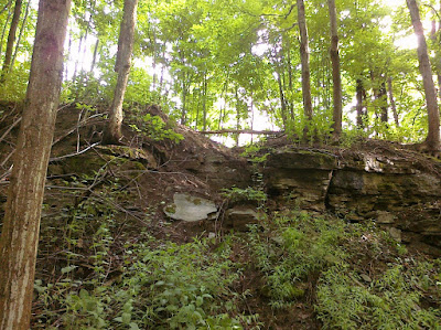
A few hundred yards east of Nelson Road the trail crosses a farm path. Just west of this crossing, there's an eroded gap at the top of the slope on the northern edge of the trail. Runoff is carrying clay soil down the slope, across the trail, and into the creek on the south side. This section is rather slippery with clay, as you can see from the pictures above. It might warrant anti-erosion measures before long.
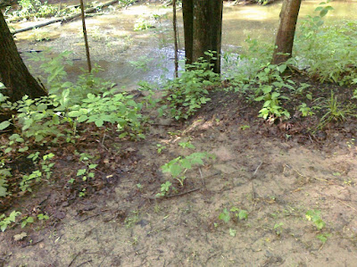
I crossed Nelson Road at 8:18 and then my feet started getting seriously wet. There's a lot of enthusiastic greenery encroaching on the trail. I was happy to see that I was wrong about the rate of erosion at a particular spot a few hundred yards west of Nelson Road: the creek hasn't eroded any more of the bank just north of the trail, as I thought it would have by now.
Between Cottons Road and the next lawn, the trail was even more overgrown. This is the section where I got soaked from the thighs down and got seeds and leaves from many plants in my shoes. It's also where I once again felt privileged to pass through the biggest grove of
bloodroot I've ever seen. The ground was completely obscured by them, for ten or fifteen feet on either side of the trail, for about a hundred feet. If you took every patch of bloodroot I've seen in my life and put them together, it wouldn't equal the size of this patch.
After the bloodroot came a pleasant patch of
mayapple. Then I passed across the lawn and through the woods, dodged many fresh cow pies, traversed the cow path and the railroad bed, and crossed Quarry Road at 9:17.
It must have rained with exceptional force on Friday night, because I noticed something I'd never seen before: all along the trail, every
daisy fleabane blossom looked sadly bedraggled, like a fifties greaser who'd gotten his pompadour all set but then got caught in a prank with a firehose. Now I wish that I'd taken a moment to unpack my camera and get some shots, but at the time I was too invested in not breaking my pace.
I reached Ingalls Corners Road at 9:44 and stopped for a few minutes to eat a Zone Bar and drink some tea. Then I forged ahead through my least favorite portion of the trail: the two and a half miles of roadside hiking between there and the Freber Road trailhead.
By then I was having a few strong reactions: consternation that I didn't seem to be maintaining anything like the pace I kept on this same hike
two years ago; sad incredulity that I seemed to be the only one taking advantage of the trail on such a lovely day; and gratitude for the lovely day itself. As I sweated my way up Seibenbaum Road under the sun that by then was blazing, a bull rose and assumed a protective stance in front of its harem.
By the time I reached the Freber Road trailhead at 10:51, I was so amazed at the time I'd made two years ago that I'd begun to wonder if I'd written it down wrong. But I knew that I'd been meticulous, so I wondered if I might actually hike from Freber to Cazenovia in a little over an hour. It seemed impossible.
I picked up the pace and made every effort not to slacken it. I crossed Carrys Hill Road at 11:15 and climbed the stairs at Bingley Road at 11:40. There was no way that I'd be in Cazenovia in twenty minutes. I prepared to be humbled by myself from two years ago.
On the trail along the falls I met a friendly bicyclist named Molly. We talked about the trail and I told her about this journal. I also had to stop and wrap my left little piggie toe for the first time. Messing around with my feet had become a real pain. Getting my socks soaked early in the hike hadn't helped them at all.
I reached Route 20 at 12:34, grabbed two slices of pizza and a Pepsi at the Sunoco station, and wolfed them down before hitting the trail at 12:48. That is correct: I will never be mistaken for a nutrition expert.
It wasn't long before I had to stop and wrap my right little piggy toe. A few weeks ago I took a twenty-five mile hike and didn't wrap that toe until it was way too late: I got a big blister and ended up losing the nail. I was not about to make the same mistake.
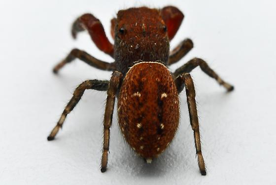
My feet kept giving me grief during most of the hike back. I had to stop, both to empty out my shoes and to re-wrap one toe or the other, with irritating frequency. Then, not far from Freber Road, I had the most frustrating missed photo opportunity in recent memory. I caught a small bit of motion on the trail that my eye immediately identified as a spider. I saw that it was a cute little orangish-brindle
salticid* of a species I’ve not seen before. I waved my hand in front of it enough to make it freeze, and then kept my eye on it as I took my pack off.
It had barely moved by the time I got my camera bag unzipped and taken the Canon macro rig out. I glanced at the camera to turn it on and make sure that the mode dial was in the right position, and when I looked back the little bugger had disappeared. I spent a few minutes blowing on the immediate area in hopes of making it twitch, combing the leaf litter, and occasionally admonishing the spider.
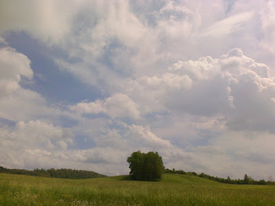
Well, I guess that got the lion’s share of my frustration out of my system, because when I broke out of the tree cover and onto the road, and saw this sky, it felt like a reward and a benediction. There’s nothing like a sky I’ve spent a whole day walking under. It feels like I can come closest to touching it because I’ve come closest to earning it.
By this time I was about as satisfied with my foot wrapping as I was going to get for this trip. I was still kicking myself for not wearing better socks, though, and I resolved to get some good hiking socks before the next trip.
I was troubled by my slowness relative to two years ago, but pleased to find myself much less achy. I could tell that I would get serious blisters out of this hike, but not the agonizing level of achiness that I had then. All the twelve- and twenty-five-mile hikes I've taken lately have gotten me conditioned.
Nothing notable happened between the splendid expanse of sky over Seibenbaum Road, and crossing Cottons Road. I was so preoccupied with getting back to the car that I didn't linger on any of the little asides that make a hike magical. Again, this is not how I would recommend that anyone do this hike.
Don't make a family commitment for the evening that leaves you zero margin for error.
A few months back I read an article about leaf galls in a natural history magazine. I don't know whether this primed me to notice them, or whether it's an exceptional year for galls, but I've been seeing them
everywhere lately! Just past the gate where the trail crosses Cottons Road and heads toward Nelson Road, I saw a magnificent selection of grape leaf galls. I'd never noticed anything like them before. The clipping shown above is the best of the bunch.
I reached my car at the Canastota trailhead at 6:12. I was disappointed that it took me so long, but very pleased that I wasn't remotely as achy as I remember feeling two years ago. And just think of how much faster I'll move after I've dropped thirty-five pounds!
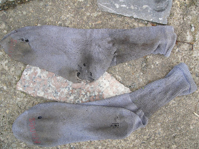
Here are the socks I wore out during this hike. The final tally of injuries was: a major blister along the bottom outside rear edge of my left foot; a largeish blister one on my right piggy toe; and some smaller ones here and there. But I'm happy to report that I didn't get any grief from my toenails this time!
*If my memory is to be trusted, the salticid that I saw was this species. Unfortunately I don't know what the species is because it's an uncategorized entry in BugGuide!