Plan your Link Trail hike!


Sunday, June 6, 2010

Abby's First Link Trail Hike!

Dylan and Abby were both exceptionally whiny during breakfast, so I was resigned to a not-so-fun hike. As it turned out, their behavior during the hike was diametrically opposed to their morning behavior. We started at the Canastota trailhead and made it all the way to the bridge over Canastota Creek, despite the fact that it started pouring right when we reached the top of the long staircase. Abby only whined a little bit when it started to rain, and that was it. She made it the whole way out and back under her own power, and Dylan was ever the gallant brother, making sure she safely navigated the slippery bits. What great kids!


Saturday, June 5, 2010

30 Miles

From 30-Mile Link Trail Hike from Canastota to Cazenovia and Back - June 5, 2010

I got into town late on Friday night, and I had made plans to have a cookout with my sister and her kids at 6:00 on Saturday night. I estimated that I had to start hiking not long after 7:00 AM in order to have time to stop for lunch and rest my feet in Cazenovia before turning around and getting back on time. This meant that I only had time for about four hours of sleep. I got up at 6:30, brewed a thermos full of tea, and hit the Canastota trailhead at 7:35.

The first thing I noticed was the forget-me-nots blossoming ten feet into the trail. White and purple-pink dame's rocket was blooming along the trail. It was a lovely day: warm and sunny. Rain had poured down the night before, so I had to be careful of slippery spots.

I don't recommend making a commitment with zero margin of error as a means of keeping yourself on schedule during a long hike. I suppose you could say that it worked for me, but I was so obsessed with finishing the hike on time that I wasn't enjoying the beginning. I don't remember too much about the first few miles.

From 30-Mile Link Trail Hike from Canastota to Cazenovia and Back - June 5, 2010


From 30-Mile Link Trail Hike from Canastota to Cazenovia and Back - June 5, 2010


From 30-Mile Link Trail Hike from Canastota to Cazenovia and Back - June 5, 2010


A few hundred yards east of Nelson Road the trail crosses a farm path. Just west of this crossing, there's an eroded gap at the top of the slope on the northern edge of the trail. Runoff is carrying clay soil down the slope, across the trail, and into the creek on the south side. This section is rather slippery with clay, as you can see from the pictures above. It might warrant anti-erosion measures before long.

I crossed Nelson Road at 8:18 and then my feet started getting seriously wet. There's a lot of enthusiastic greenery encroaching on the trail. I was happy to see that I was wrong about the rate of erosion at a particular spot a few hundred yards west of Nelson Road: the creek hasn't eroded any more of the bank just north of the trail, as I thought it would have by now.

Between Cottons Road and the next lawn, the trail was even more overgrown. This is the section where I got soaked from the thighs down and got seeds and leaves from many plants in my shoes. It's also where I once again felt privileged to pass through the biggest grove of bloodroot I've ever seen. The ground was completely obscured by them, for ten or fifteen feet on either side of the trail, for about a hundred feet. If you took every patch of bloodroot I've seen in my life and put them together, it wouldn't equal the size of this patch.

After the bloodroot came a pleasant patch of mayapple. Then I passed across the lawn and through the woods, dodged many fresh cow pies, traversed the cow path and the railroad bed, and crossed Quarry Road at 9:17.

It must have rained with exceptional force on Friday night, because I noticed something I'd never seen before: all along the trail, every daisy fleabane blossom looked sadly bedraggled, like a fifties greaser who'd gotten his pompadour all set but then got caught in a prank with a firehose. Now I wish that I'd taken a moment to unpack my camera and get some shots, but at the time I was too invested in not breaking my pace.

I reached Ingalls Corners Road at 9:44 and stopped for a few minutes to eat a Zone Bar and drink some tea. Then I forged ahead through my least favorite portion of the trail: the two and a half miles of roadside hiking between there and the Freber Road trailhead.

By then I was having a few strong reactions: consternation that I didn't seem to be maintaining anything like the pace I kept on this same hike two years ago; sad incredulity that I seemed to be the only one taking advantage of the trail on such a lovely day; and gratitude for the lovely day itself. As I sweated my way up Seibenbaum Road under the sun that by then was blazing, a bull rose and assumed a protective stance in front of its harem.

By the time I reached the Freber Road trailhead at 10:51, I was so amazed at the time I'd made two years ago that I'd begun to wonder if I'd written it down wrong. But I knew that I'd been meticulous, so I wondered if I might actually hike from Freber to Cazenovia in a little over an hour. It seemed impossible.

I picked up the pace and made every effort not to slacken it. I crossed Carrys Hill Road at 11:15 and climbed the stairs at Bingley Road at 11:40. There was no way that I'd be in Cazenovia in twenty minutes. I prepared to be humbled by myself from two years ago.

On the trail along the falls I met a friendly bicyclist named Molly. We talked about the trail and I told her about this journal. I also had to stop and wrap my left little piggie toe for the first time. Messing around with my feet had become a real pain. Getting my socks soaked early in the hike hadn't helped them at all.

I reached Route 20 at 12:34, grabbed two slices of pizza and a Pepsi at the Sunoco station, and wolfed them down before hitting the trail at 12:48. That is correct: I will never be mistaken for a nutrition expert.

It wasn't long before I had to stop and wrap my right little piggy toe. A few weeks ago I took a twenty-five mile hike and didn't wrap that toe until it was way too late: I got a big blister and ended up losing the nail. I was not about to make the same mistake.

My feet kept giving me grief during most of the hike back. I had to stop, both to empty out my shoes and to re-wrap one toe or the other, with irritating frequency. Then, not far from Freber Road, I had the most frustrating missed photo opportunity in recent memory. I caught a small bit of motion on the trail that my eye immediately identified as a spider. I saw that it was a cute little orangish-brindle salticid* of a species I’ve not seen before. I waved my hand in front of it enough to make it freeze, and then kept my eye on it as I took my pack off.

It had barely moved by the time I got my camera bag unzipped and taken the Canon macro rig out. I glanced at the camera to turn it on and make sure that the mode dial was in the right position, and when I looked back the little bugger had disappeared. I spent a few minutes blowing on the immediate area in hopes of making it twitch, combing the leaf litter, and occasionally admonishing the spider.

From 30-Mile Link Trail Hike from Canastota to Cazenovia and Back - June 5, 2010


From 30-Mile Link Trail Hike from Canastota to Cazenovia and Back - June 5, 2010


From 30-Mile Link Trail Hike from Canastota to Cazenovia and Back - June 5, 2010


Well, I guess that got the lion’s share of my frustration out of my system, because when I broke out of the tree cover and onto the road, and saw this sky, it felt like a reward and a benediction. There’s nothing like a sky I’ve spent a whole day walking under. It feels like I can come closest to touching it because I’ve come closest to earning it.

By this time I was about as satisfied with my foot wrapping as I was going to get for this trip. I was still kicking myself for not wearing better socks, though, and I resolved to get some good hiking socks before the next trip.

I was troubled by my slowness relative to two years ago, but pleased to find myself much less achy. I could tell that I would get serious blisters out of this hike, but not the agonizing level of achiness that I had then. All the twelve- and twenty-five-mile hikes I've taken lately have gotten me conditioned.

Nothing notable happened between the splendid expanse of sky over Seibenbaum Road, and crossing Cottons Road. I was so preoccupied with getting back to the car that I didn't linger on any of the little asides that make a hike magical. Again, this is not how I would recommend that anyone do this hike. Don't make a family commitment for the evening that leaves you zero margin for error.

From 30-Mile Link Trail Hike from Canastota to Cazenovia and Back - June 5, 2010


A few months back I read an article about leaf galls in a natural history magazine. I don't know whether this primed me to notice them, or whether it's an exceptional year for galls, but I've been seeing them everywhere lately! Just past the gate where the trail crosses Cottons Road and heads toward Nelson Road, I saw a magnificent selection of grape leaf galls. I'd never noticed anything like them before. The clipping shown above is the best of the bunch.

I reached my car at the Canastota trailhead at 6:12. I was disappointed that it took me so long, but very pleased that I wasn't remotely as achy as I remember feeling two years ago. And just think of how much faster I'll move after I've dropped thirty-five pounds!

From 30-Mile Link Trail Hike from Canastota to Cazenovia and Back - June 5, 2010


Here are the socks I wore out during this hike. The final tally of injuries was: a major blister along the bottom outside rear edge of my left foot; a largeish blister one on my right piggy toe; and some smaller ones here and there. But I'm happy to report that I didn't get any grief from my toenails this time!


*If my memory is to be trusted, the salticid that I saw was this species. Unfortunately I don't know what the species is because it's an uncategorized entry in BugGuide!

Saturday, May 15, 2010

Maintenance hike on the Irish Hill section

From Link Trail Hike, Irish Ridge Road to south of Damon Road - May 15, 2010


As of last November I'm the steward of the mile and a half section of trail between Irish Hill Road and Damon Road. This was my first hike of the year through the whole thing, so I was excited at the prospect of doing some trail-clearing. I parked at the crook of Irish Hill Road and hit the trail at about 5:00. The first stream crossing was vastly easier than it was in March, when the water was twice as high from the spring melt.

Carrying two axes and a machete was awkward, but I soon discovered a way to make it less so. I remembered that my cheap little worn-out day pack had a carry loop on top. I stuck both axes in there and they stayed well enough for the purposes of this hike. I need to come up with a safer and more secure arrangement, though.

Red wintergreen berries provided the first cheerful wink of color along the trail. Withering trout lily leaves testified to yellow that had passed, and cinquefoil leaves promised more yellow to come.

I could hardly believe how soon I'd passed over the stream crossing that Grace and I helped redirect on July 4th. In March, when I was gingerly making my way through, over and around mud and runoff with a six-year-old, it seemed like a much longer hike!

From Link Trail Hike, Irish Ridge Road to south of Damon Road - May 15, 2010


I passed out of the woods and headed south on the wider section that parallels the hedgerow. I found that part more delightful, not just because I've spent less time on it, but because of the forget-me-nots sprinkled liberally along the verges. The way they grew partially obscured among the grasses and tiny maple trees made me think of faeries.

From Link Trail Hike, Irish Ridge Road to south of Damon Road - May 15, 2010


Along with the touch-me-nots I saw lots of dandelions, both blooming and seeding. Once again I was rewarded for taking the time to get some macro shots of a flower that I've seen hundreds of millions of times: when I looked at these pictures later, it was like seeing a dandelion for the first time.

From Link Trail Hike, Irish Ridge Road to south of Damon Road - May 15, 2010


From Link Trail Hike, Irish Ridge Road to south of Damon Road - May 15, 2010


From Link Trail Hike, Irish Ridge Road to south of Damon Road - May 15, 2010


From Link Trail Hike, Irish Ridge Road to south of Damon Road - May 15, 2010


I stopped to take pictures of violets, apple blossoms, and a bird's nest made of mud and straw that I found just a step off the trail, about six feet off the ground in an apple tree. Now I wish I'd have taken pictures of the wild mustard that stitched the trail with yellow. What new intricacies would a closeup have revealed? I'll make a point to find out next time.

From Link Trail Hike, Irish Ridge Road to south of Damon Road - May 15, 2010


From Link Trail Hike, Irish Ridge Road to south of Damon Road - May 15, 2010


Now that I've looked at the shots, I have to say that the most rewarding of all the photographic subjects on this hike were last year's burdock. I love the way the seeds were so clearly waiting to be shaken loose by an animal attempting to worry the burr free from its fur, and I'm fascinated by the golden yellow hooks that I never would have noticed if not for the macro shots.

Even more so than the forget-me-nots, the copses of myrtle made the trail magical. There are large patches of open, shady woods along the western edge of the trail that resemble nothing so much as a gently undulating sea of periwinkle. In one particularly dramatic spot, the remains of an old tree jut up from a mound so that the dark green sea seems to wash against a craggy island spire.

From Link Trail Hike, Irish Ridge Road to south of Damon Road - May 15, 2010


When I saw the treefall across the trail a few hundred yards north of Damon Road, my heart rejoiced. It's been far too long since I've had the opportunity for some real trail-clearing. This one was nothing compared to some of the monster blowdowns I cleared in the Adirondacks back around the early aughts, but then again I'm not in my best shape right now, so it was a good workout.

My father's words about always clearing the ground before swinging the axe echoed in my ears as I went to work with the machete. I got the little stuff cleared away and then went to work with the axe.

It's always much more challenging to chop through logs when they're suspended over the ground like these were: the position puts you at a muscular disadvantage, and the lack of bracing means that a lot of your striking force is dissipated. So naturally I place my first cut to bring down the entire length of log that needs to be cleared.

I tend to cut up logs so that the pieces are right at the upper limit of what I can move. This always feels a bit weird because I'm minimizing the time I spend chopping, an activity that I enjoy more than almost anything. But it also makes it as difficult as possible for me to wrestle the pieces off the trail. This is exactly what I want, because it gives me the best possible full-body workout.

From Link Trail Hike, Irish Ridge Road to south of Damon Road - May 15, 2010


From Link Trail Hike, Irish Ridge Road to south of Damon Road - May 15, 2010


So I got that big log up on the bank where it couldn't possibly jump out and bite anyone, and took some shots of my kill. I just looked back at the time stamps on the pictures, and found that fifty-nine minutes passed between the last shot of the treefall and the first shot of the cleared trail. Under an hour: not bad for someone so out of shape.

From Link Trail Hike, Irish Ridge Road to south of Damon Road - May 15, 2010


From Link Trail Hike, Irish Ridge Road to south of Damon Road - May 15, 2010


When I reached Damon Road there was still plenty of sunlight, so I decided to continue south for a while. This section was even more delightfully forget-me-not-ridden, but another problem soon soured the experience: it was a mud pit, and it was obvious that ATVs were the reason. I made my winding way, avoiding the mud as best I could, but still wound up with wet feet by the time I turned around, probably less than a mile in.

On the way back I met a hiker with her dogs and had a pleasant conversation about the trail. When I reached my car and headed back toward Oneida, I was shocked to see that it was 8:30. I'd sure had a lot of fun on the trail for three and a half hours to have flown by so fast!

Tuesday, February 23, 2010

One Last Time Capsule from Summer


Here's a third time capsule, this one from August 22nd. For more pictures from this hike, see the Picasa web album.

Dylan and I walked east from Nelson Road. It was a hot day, so when it started raining we didn't mind much. The only problem was that it kept me from taking my camera out toward the end of the hike. So I didn't get any pictures of Dylan or me, nor of the rolled leaves that I noticed at the beginning of the hike.

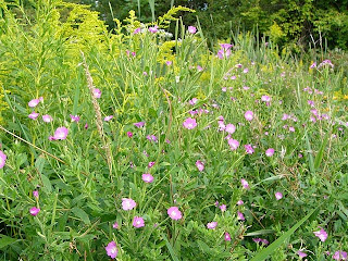
What I did get was some shots of a wildflower I'd never seen before. Just a minute or two into the hike I noticed that the marshy area to the south of the trail was full of magenta blossoms that I couldn't immediately identify. When I went closer, I was surprised to find that I still couldn't identify them. After years of walking all over the hills and ravines south of Oneida I didn't think there was a showy wildflower I hadn't seen. I was wrong.


I just found the flower in my Peterson's Guide to Wildflowers. It's hairy willow-herb (Epilobium hirsutum).

Monday, February 22, 2010

Touch-Me-Not

Here's another time capsule, this one from September 19th. It was a gorgeous, sunny day and I took Dylan and Abby on a short hike west from Nelson Road. It was Abby's first hike on the Link Trail, and the timing couldn't have been better. The touch-me-nots were ready to pop, and the kids duly popped them to their little hearts' content.

I just looked up touch-me-nots, aka jewelweed, in Wikipedia and was surprised to find that what I thought was one species is actually two: orange jewelweed (Impatiens capensis) and yellow jewelweed (Impatiens pallida).


Saturday, February 13, 2010

Dylan's First Link Trail Snowshoe Hike


For many more pictures from this hike, see the Picasa web album.

I hadn't been back to Oneida since December so both Dylan and I were looking forward to getting back to the Link Trail. I was particularly eager to try snowshoeing with Dylan. His parents had gotten him a pair a year or two ago, but I hadn't had any excuse to take him out on them.

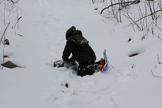
We parked on the side of Quarry Road and I gave Dylan a little instruction on how to work the straps. I got my own somewhat more extensive bindings strapped on and we hit the trail. Dylan immediately started falling down and complaining, but not too loudly. As usual, I framed it as a learning experience -- a phase he'd have to go through in order to someday climb snow-covered mountains. I stressed that although wearing the snowshoes is tiring for him now, next time it will be easier.


Queen Anne's lace (Daucus carota)

As soon as we got onto the trail I saw a great photo op: several Queen Anne's lace plants, each one cupping a small load of snow. I love plants like this that stand like sere watchmen through the winter. They manage to seem at once sad, funereal and graceful.

Here's some interesting information about Queen Anne's lace from the Wikepedia entry.
Uses

Like the cultivated carrot, the wild carrot root is edible while young, but quickly becomes too woody to consume. A teaspoon of crushed seeds has long been used as a form of birth control; its use for this purpose was first described by Hippocrates over 2,000 years ago.[citation needed] Research conducted on mice has offered a degree of confirmation for this use—it was found that wild carrot disrupts the implantation process, which reinforces its reputation as a contraceptive.[2] Chinese studies have also indicated that the seeds block progesterone synthesis, which could explain this effect.[citation needed]

As with all herbal remedies and wild food gathering, extra caution should be used, especially since the wild carrot bears close resemblance to a dangerous species Water Hemlock. The leaves of the wild carrot can cause phytophotodermatitis, so caution should also be used when handling the plant.

The wild carrot, when freshly cut, will draw or change color depending on the color of the water it is in. Note that this effect is only visible on the "head" or flower of the plant. Carnation also exhibits this effect. This occurrence is a popular science experiment in primary grade school.
The following is from the book A Guide to Nature in Winter by Donald W. Stokes. I stumbled upon it in the library today, and it's so delightful that I ordered a used copy from Amazon. I'm looking forward to reading from it to Dylan.
The seeds, small and lined with four rows of spines, are dispersed by animals, whose fur picks up the seeds as they pass by. Wild Carrot seeds can be gathered and steeped in hot water to make good-tasting tea -- fun to make after a winter walk. If you bite one of the seeds in the field you will find its flavor similar to that of cooked carrots. The seeds can be used as a spice; in fact, many plants from which we get spices are related to Wild Carrot, such as Caraway, Fennel, Coriander, Anise, and Parsley.


American Bladdernut (Staphylea trifolia)

See the Picasa web album for more shots of withered seed pods and fruit.

My second photographic subject was a brindle seed pod. It reminds me of a Chinese lantern plant, although this was a shrub. I eventually found it in Graves's "Illustrated Guide to Trees and Shrubs".


Rocks blackened by manganese oxidation?

I looked up to the rock cliff to the left and saw another teaching opportunity. I pointed out the rocks to Dylan and told him that the rocks we've seen fallen along the trail came from up there. I said "Look at how some parts of the rocks are blackened, and some parts are light brown. The black parts are black because of oxidation. That's a chemical process that you won't understand for a long time, but the point is that when some things are exposed to air they turn black. The parts of the rock that have been exposed to air for a long time are black, but the light brown parts haven't. That's how you can tell that rocks broke off from those parts recently."

I know very little chemistry, so I wanted to check up on the assertion I made to Dylan that the black parts of the rock were black because of oxidation. A spot of Googling led me to the Pro Trails page on Petroglyph National Monument. The stones there, into which the Ancestral Pueblos carved their petroglyphs, certainly look similar to what Dylan and I saw. That page says that "The dark desert varnish on the face of the basalt rocks was caused by the oxidation of minerals such as manganese and iron."

Grace and I were dredging our memories of chemistry in an attempt to figure out exactly why an oxidation process would change the color of a stone. Eventually I found an interesting article about manganese and its several oxidation states. Then I looked at the Wikipedia entry on desert varnish, which says the following.
Desert varnish forms only on physically stable rock surfaces that are no longer subject to frequent precipitation, fracturing or wind abrasion. The varnish is primarily composed of particles of clay along with iron and manganese oxides.[1] There is also a host of trace elements and almost always some organic matter. The color of the varnish varies from shades of brown to black.[2]
So although the rocks along the trail certainly look like they were discolored by the same process of manganese oxidation, I'd need to talk to a geologist or a chemist to be sure.


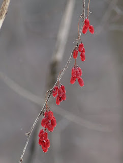
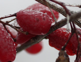
Common barberry (Berberis vulgaris)

Gosh I love the intellectual process sparked by traipsing about a trail and looking at stuff that catches my eye. And this particular process was spurned by the most unintellectual of exclamations: "Red!"

For decades I've found that what one finds in nature is exponentially proportional to how hard one looks. In spring after the snow melts and the residue of winter coats every surface, it's easy to look at the landscape and see nothing but brown. Likewise, when the leaves have dropped and the world seems to have devoted all its energy to quiescence like a sullen child, it's easy to see nothing but stark white overlaid with shades of grey. But that's just us casting our own mental shadows onto a system that knows nothing of our dourness. Nature is always processing. Nature's always got plenty of red.

Don't believe me? In the spring take a moment to look past the road scum. Gaze into the brush. Focus on the midground. Look for that hazy strip of red -- the constellation of reddish tinges from all the buds on all the shrubs focusing their energy like a legion of tiny green barbarians painting themselves in preparation for the frenzied yearly assault on entropy.

But you don't have to wait until spring. Hop in the car and park along Quarry Road. Hike a little ways southwest on the Link Trail. At first you'll just see white and grey. I did. But if you're like me, you'll notice a little red and then start seeing more. Before long you'll be seeing a barrage of red: red that jumps out at you, screaming at you, daring you to call it "quiescent".

And if you're like me, you'll be drawn to the source of the red: thorny shrubs, each with a host of ruby berries still hanging from them. You'll take lots of pictures. Then, later, as you're spending hours going through more than nine hundred pictures and choosing which ones to show people, you'll fume at yourself for doing so.

Then you'll get curious as to what exactly the buggers are. It'll bother you that you've seen them all your life and all you really know is what your father told you: don't eat them because they might be poisonous. So you'll Google "thorny shrub red berries" and several variations on such wording. You'll find nothing.

Eventually you'll find yourself at your local library thumbing through copies of Peterson's "Field Guide to Trees and Shrubs" and Graves's "Illustrated Guide to Trees and Shrubs". On page 119 of the latter you'll find the following.


Then you'll do a bit more Googling and feel a sense of wonder. The Wikipedia entry for Berberis vulgaris is so fascinating that I'm posting a big chunk of it here.
Culinary uses

The berries are edible, and rich in vitamin C, though with a very sharp flavour; the thorny shrubs make harvesting them difficult, so in most places they are not widely consumed. They are an important food for many small birds, which disperse the seeds in their droppings.

A widely available Russian candy called Барбарис (Barberis) is made using extract from the berries, which are pictured on the wrapper.

The Zereshk (زرشک) or sereshk is the Persian name for the dried fruit of Berberis vulgaris, which are widely cultivated in Iran. Iran is the largest producer of zereshk and saffron in the world. Zereshk and saffron are produced on the same land and the harvest is at the same time.

The South Khorasan province in Iran is the main area of zereshk and saffron production in the world. Barberry cultivation in Iran is concentrated there, especially around Birjand and Qaen. About 85% of production is in Qaen and about 15% in Birjand. According to evidence the cultivation of seedless barberry in South Khorasan goes back to two hundred years ago.[1]

A garden of zereshk is called zereshk-estan.

Zereshk is widely used in cooking, imparting a tart flavor to chicken dishes. It is usually cooked with rice, called zereshk polo, and provides a nice meal with chicken. Zereshk jam, zereshk juice, and zereshk fruit rolls are also produced in Iran.
The entry goes on to describe the plant's use in alternative medicine and its historical impact on the United States wheat crop. The USDA Forest Service Fire Effects Information System entry for Berberis vulgaris goes into more detail on this subject.
Eradication efforts and effects on local distributions: Soon after the introduction and escape of common barberry in New England, colonists determined it was responsible for dramatic reductions in wheat crop yields [28]. Common barberry is an alternate host for cereal stem rust (Puccinia graminis). As a host, common barberry provides an inoculum source and a sexual reproduction site for stem rust (Leonard 2001 cited in [71]). When common barberry grows near cereal crops (‹330 feet (100 m) away) (Roelfs 1985 cited in [71]), it can support the development of new genotypes able to adapt and attack rust-resistant crops (Leonard 2001 cited in [71]). Earlier reports suggested that common barberry in urban areas was also able to spread stem rust to other grasses that eventually passed it on to wheat crops [80], suggesting there was no safe distance between common barberry and cereal crops. During epidemic stem rust outbreaks, wheat yield losses up to 70% were reported [71]. In 1916, stem rust was considered the principal reason for a 200 million bushel reduction in wheat yields for Minnesota, North Dakota, South Dakota, and Montana [80].

In the 18th century, the New England colonists of Connecticut, Massachusetts, and Rhode Island wrote laws restricting the planting and spread of common barberry. Over time many other states developed laws against the sale, transport, and planting of new barberry (Berberis spp.) plants and for the removal of established plants. It was not until 1918, after "devastating" wheat losses to stem rust, that federal laws and funding were devoted to eradication. Eradication projects and funding between 1918 and 1942 led to the destruction of 309,645,502 landscape, escaped, and nursery plants from the 964,000 mile² (2,497,000 km²) eradication area that included nearly all of the North American spring-wheat growing areas [28]. Between 1935 and 1950, there were 150,087,197 common barberry or American barberry (B. canadensis) shrubs destroyed in West Virginia [84]. By 1956, nearly 500 million barberry shrubs were killed on 149,318 properties in 19 states [12]. Widespread barberry eradication was "gradually phased out" by 1980 [71]. It is important to note that scattered common barberry populations persist in several areas of North America, and the potential for long-distance seed dispersal by birds makes monitoring and early detection of common barberry important to long-term control.
It's amazing to me that I can walk out onto the trail and obtain a profound connection to world and local history through the simple expedient of looking up teasel, St. John's wort, Queen Anne's lace or Common Barberry.


Dylan bracing himself against one of the fallen rocks that I'd told him about at the beginning of the hike.

Dylan got tired quickly, as you'd expect of a kid who's not used to snowshoes. He asked to turn around before we got to the quarry. At about that time I noticed a lot of vertical cracks in the rocks on the southern slope, so I took advantage of another teaching opportunity.

I said to Dylan "You know why the rocks fall off those cliffs? When it rains, the water goes down into the cracks in the rocks. And then when winter comes and it gets cold, the water freezes and expands. Do you know what that means?"

Dylan immediately answered "It gets bigger." Ah. I remember this feeling. It's the differential between adult perception of time and youthful passage of time. I still think of Dylan as four years old, but he just turned six. A lot of neurological development happens between four and six--a lot of neurological development that I've taken part in. Who knows, maybe I'm the one who told him what "expands" means during an earlier hike.

So I continued with my explanation of how water fills cracks in the rocks, freezes, expands, and makes the rocks fall apart. I remember my father telling me this. I love coming full circle.


Snowdrift ridge along the top of the slope and the northern edge of the trail

This wavy soft-serve snow crest prompted me to attempt the most-difficult-to-teach lesson of the day. I pulled a trick I used to pull on Morgan when she was about eight years old and I was attempting to teach her the concept of surface-area-to-volume ratios. I said to Dylan "I want to tell you about something but it's very hard to understand." I never even got to the "I'll try if you think you're ready to listen" part. He said something like "I want to hear it."

So I tried to translate what I know about the behavior of particles suspended in a fluid stream into kidspeak. Which is tricky, because "I just barely passed" is the polite version of the description of my performance in the fluid dynamics course I took eighteen years ago at Cornell. The not-so-polite version is "I was so completely clueless that I never should have passed at all."

What came out was something like this: "The wind comes up the slope and then, here where the ground flattens out, the wind slows down because it has to fill this whole space. And when the air is going slower, it can't hold as much snow, so it dumps it right here along the top of the slope."

There'll be more teaching opportunities.